Phone & WhatsApp

0098-902-877-0569

Mount Sahand in Iran: A Trekker’s Guide to the “Bride of Iranian Mountains”

Sahand Mountain

Table Of Content

Nestled in the heart of northwestern Iran, Mount Sahand stands as a majestic volcanic giant, revered as the “Bride of Iranian Mountains” for its snow-capped peaks and lush, flower-strewn slopes. Located just 50 kilometers south of Tabriz, this dormant stratovolcano rises to an elevation of 3,707 meters, dominating the skyline of East Azerbaijan Province. Beyond its geological grandeur, Sahand holds deep cultural significance, woven into Persian poetry, folklore, and spiritual traditions. For trekkers, it offers a unique blend of challenging trails, serene alpine meadows, and glimpses into rural Iranian life.

The mountain’s volcanic legacy has shaped its fertile valleys, creating a haven for biodiversity and sustaining centuries-old villages like Kandovan, famed for its cave dwellings. Whether you’re drawn by the allure of summiting a volcanic peak, exploring wildflower fields, or immersing in local culture, Mount Sahand promises an unforgettable adventure. This guide unpacks everything you need to know—from its fiery geology to practical trekking tips—for those planning trekking tours in Iran.

Geology and Natural Features of Mount Sahand

The geological characteristics of Mount Sahand extend throughout the Zagros and Azerbaijan territories. The mountain represents a typical dormant stratovolcano that developed its main structure between 12 million and 2 million years ago during the Miocene and Pliocene periods. The mountain consists mainly of andesitic and dacitic lava flows, pyroclastic deposits and volcanic domes as its main geological features.

The past millions of years of erosion have been sculpting its present form, which has steep ridges and deep furrows as the erosion continued to cut through its present form. The Mountain produces several hot springs and mineral-filled waters that appear on its sides, which are evidence of the active geothermal activity.

The people of Iran frequently draw comparisons between Sahand and other inactive volcanoes, which include Sabalan and Damavand. Sahand is an older volcano, which has been eroded more, whereas Damavand has not erupted since its last eruption. The great Mount Sahand is part of the Sahand-Bazman volcanic arc.

The Sahand Protected Area currently safeguards extensive sections of the mountain, which serve as a habitat for multiple animal species, including Armenian mouflon, golden eagles, wolves and rare Caucasian leopards. Sahand, Iran, attracts both locals and tourists because it combines volcanic beauty with diverse wildlife and cultural heritage, making it a bucket-list destination for adventure tours in Iran.

also read: iran ski resorts

Mount Sahand Elevation & Physical Features

sahand mountain iran

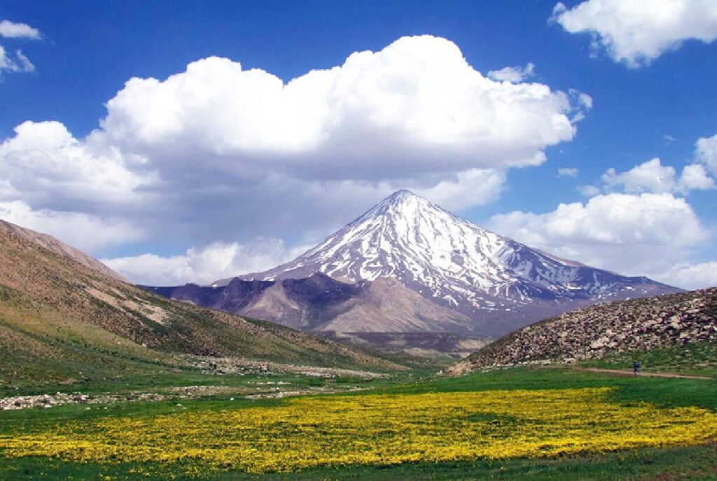
The Mount Sahand elevation reaches 3,707 meters at its highest point, the peak known as Kamal. Sahand stands as the highest peak in East Azerbaijan Province because it has 17 summits that exceed 3,000 meters in height. The highest peak, known locally as Jam Daghi, provides panoramic views of Tabriz and Lake Urmia, which are most impressive during the early morning hours.

Sahand Mountain shows its status as an inactive stratovolcano through its display of eroded craters, ancient lava flows and jagged ridges which have been shaped by thousands of years of weathering. This can be seen in the translation of Sahand, meaning “powerful.” The mountain reaches a height of 1826 meters, which classifies it as an ultra-prominent peak that draws mountaineers who want to experience challenging, yet non-technical climbing routes.

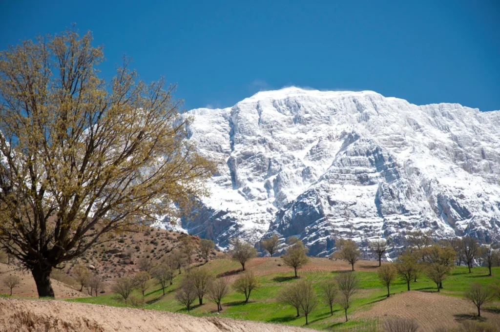
This mountain chain offers climbing opportunities since it has alpine meadows which are covered with wild flowers and glacial lakes, and mineral-rich hot springs with superior health benefits. Sahand Mountain has great slopes that offer climbers a perfect climbing setup consisting of mountain outcrops and smooth slopes to those intermediate climbers seeking to explore other natural environment features.

Climbing and Exploration of Sahand Mountain

The Mount Sahand climbing experience delivers climbers rewarding experiences through its established climbing routes. The main trail begins at Varkaneh village, located on the southern slopes and extends for 12 kilometers through meadows and scree until it reaches the mountain peak. The path requires 6 to 8 hours to reach its destination, which starts at approximately 2200 meters. The path demands moderate fitness because it requires climbers to ascend to higher elevations from their starting point.

The northern Gonbad-e Kavous Trail provides alternative walking paths that allow travelers to reach nomadic camps and view waterfalls while experiencing a multi-day camping trip at Gushayesh Spring. The path requires intermediate difficulty because loose volcanic scree creates slip hazards, but climbers do not need to use ropes or ice axes.

The best months to visit are May through June when spring flowers bloom and temperatures remain between 10 and 20 degrees Celsius. The best visiting times for September through October display autumn colors, while summer brings consistent weather patterns and winter only suits experienced climbers who want to navigate through deep snow and avalanche conditions.

Recommended equipment you should bring includes sturdy boots, together with layered clothing, a GPS, a first-aid kit and sufficient water needed for altitude sickness treatment. Safety requires people to use weather applications, like Windy, together with local guides for navigation and to register themselves with Tabriz authorities because no permits are needed. Exploration extends to cultural sites like the 13th-century Sheikh Hassan Hermitage, which combines a fun adventure with unique heritage, be sure to visit our ski tour iran page and enjoy a thrilling and unforgettable journey

Your trip to Iran begins smoothly with our Iran airport transfer services.

Sahand Mountain, Iran ― Location & Geography

mount sahand elevation

The mountain of Sahand, in Iran, is in Eastern Azerbaijan province, which determines its geographical boundaries. The provincial capital, which is called Tabriz, is located 50 kilometers north of Mount Sahand, which rises above the landscape and shapes the region’s weather patterns and farming practices.

The location of this breathtaking place is established through its geographic coordinates, which are 37°43′51″N 46°30′00″E. Day trips from the city become possible because of its location, which is positioned in the south of Tabriz. It provides access to nearby valleys that contain the Sahand Chay rivers, which nourish productive farmland and orchards.

The mountain’s proximity to other points enhances its appeal. The distance between Lake Urmia and its westernmost point measures approximately 95 kilometers, which rewards visitors with extensive views from its elevated sections. Regarding the distance from Varzaqan to Sahand Mountain, Varzaqan lies approximately 100 kilometers northeast of the Mountain, which makes Sahand accessible for local residents to visit the peak.

The mining town of Varzaqan is seismic due to the tectonic movement around it which creates seismic activities which reveal how the mountain Sahand is related to the East Azerbaijan geographic region. Travelers can reach the base via highways from Tabriz, passing through picturesque villages that display the true Azeri cultural heritage.

Best Time to Climb Mount Sahand

Timing is critical for a successful Sahand trek. Late spring (May–June) is ideal, as melting snow reveals blooming meadows and temperatures hover between 10°C and 20°C. By July, the alpine flowers fade, but summer offers stable weather for summit attempts.

Autumn (September–October) paints the slopes in golden hues, though early snowfall can close higher trails. Winter transforms Sahand into a snowy wonderland, but sub-zero temperatures and avalanche risks make it suitable only for experienced mountaineers with specialized gear.

Avoid the rainy season (April) when trails turn muddy, and fog obscures visibility. For photographers, early mornings in spring or autumn provide magical lighting over Sahand’s volcanic ridges. If you enjoyed exploring the Sahand Mountain guide and are looking for a hiking and sightseeing experience at another natural masterpiece of Iran, don’t miss the chance—book our Sabalan Tour now for an unforgettable journey to Mount Sabalan.

Before you pack your bags, take a moment to complete your Iran visa application.

Safety and Travel Tips for Sahand Trekking

  1. Physical Preparation: Build endurance with cardio exercises; altitude, though moderate, can strain untrained hikers.

  2. Gear Essentials: Pack sturdy boots, layered clothing, a GPS device, and a first-aid kit. Nights are chilly even in summer.

  3. Altitude Awareness: Acclimatize in Tabriz (1,350 meters) before ascending. Hydrate frequently to avoid altitude sickness.

  4. Local Guides: Engage certified guides familiar with Sahand’s trails and weather patterns.

  5. Weather Checks: Sudden storms are common. Monitor forecasts via apps like Windy.

  6. Respect Nature: Carry out trash, avoid disturbing wildlife, and stick to marked paths to prevent erosion.

Our Iran Budget Tours let you see more, spend less, and create memories that last a lifetime.

FAQs About Trekking Mount Sahand

Is Mount Sahand suitable for beginner trekkers?

Yes! Day hikes on lower slopes are beginner-friendly. Summit climbs require moderate fitness.

No permits are required, but registering with local authorities in Tabriz is recommended for safety.

Absolutely! Pair it with trips to the Alborz Mountains or the deserts of Yazd for a diverse Iranian adventure.

More Places

Travel Tips

Leave a Reply

Your email address will not be published. Required fields are marked *

Share